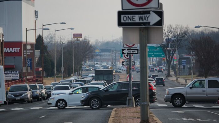
Anyone who has walked or biked New York Avenue NE east of Florida Ave will agree that the current loud, fast, car-centric conditions make it an uninviting place for people walking and biking. Frankly, it’s a pretty unpleasant road even when you’re inside a car.
The good news:
In late June, DDOT shared an updated design for an improved streetscape and trail to improve the experience of anyone traveling the corridor. Compared to the 2017 design, this new design could be completed much more quickly (just 7 years vs. 20 years), requires far fewer land acquisitions (about ½ the cost), and includes a 10-foot shared use path on the north and south sides of New York Avenue NE.
The bad news:
This new design is very utilitarian. It fails to achieve the original vision of a linear park, doesn’t connect to the Metropolitan Branch Trail, Union Market or the 9th Street Bridge, and doesn’t plan ahead for future connections and future volumes of trail users – missing the mark to reimagine the experience for people who would benefit from a world-class trail for walking and biking along New York Avenue NE.
What is the scope of the project?
DDOT is working to create safe places to walk and bike along New York Ave NE and in some of the neighborhoods to the south from Florida Avenue NE east to Bladensburg Road NE.
How did we get here?
In 2015, the Rails to Trails Conservancy, with support of WABA, developed a concept plan for a New York Avenue Trail. In 2016, DDOT began a feasibility study and collected significant public input to inform the concept plan released in late 2017, now called Alternative 1. Recently, DDOT shared details on Alternative 2 – the new 2023 design. Alternative 2 includes some improvements for people walking and biking that would be delivered more quickly at a lower cost – but the proposed bike and pedestrian improvements are uninspiring, resulting in what is essentially a wider sidewalk on both sides of New York Avenue, without most of the trees, space, and people-focused amenities that would attract people to spend time there.
More about Current Design
The Alternative 2 – 2023 Updated Design features a 10ft wide path on the north and south of New York Ave NE. By infrastructure project standards, it is a modest design, with a price tag at about ½ the cost of the previous design ($25M vs. $50M+) and a timeline about ⅓ as long (7 years vs. 20 years). Despite those highlights, the updated design leaves a lot to be desired.
Through the corridor, the design widens existing sidewalks into a 10ft shared use trail or builds new facilities where they didn’t already exist. On the north side, the trail is immediately adjacent to the noise and stress of travel lanes, separated only by a crash-barrier. On the south a planting strip provides some buffer from traffic. But the proposed design does NOT: connect to the Metropolitan Branch Trail, connect to Union Market, address the 9th Street bridge, or plan to connect to other projects to the east, including along Bladensburg Road NE.
To improve the design for people walking and biking, an updated design should:
- Realize the vision for a linear park: Return to the north side linear park vision where the right of way allows, even where that requires displacing a municipal parking lot.
- Connect to the MBT: Provide a seamless, direct, low-stress bicycle route to the Metropolitan Branch Trail via 4th st alley, 4th st, or through NPS maintenance facility.
- Prioritize safety: Reduce possible points of conflict between drivers and pedestrians, especially across intersections such as the crossing at Montana Avenue NE.
- Build for the future: Where possible, the New York Avenue Trail should be widened to accommodate future volumes of trail users from 10 ft to 12 to 14ft wide. The claim that the 10-foot wide design, just like the MBT, isn’t sufficient – as we already see at many points along the MBT where trail users are constrained by the limited width of the trail. On the east end, avoid creating obstacles that would prevent or preclude future extension to and across the Anacostia River.
Remind me: What was included in the Alternative 1: 2017 Design? DDOT’s Alternative 1 – 2017 Design proposed a separated two-way cycle track on the north side and a shared use path on the south side, creating a continuous route from Met Branch Trail to the Arboretum, with improved pavement markings, road crossings, and signage, new sidewalks, improvements to intersections, new wayfinding signage, and street furniture.
All of that sounds great, but there’s a huge sticking point: the 2017 design is tied to the planned, but unbuilt Virginia Railway Express (VRE) rail yard and the New City development at West Virginia Ave, which is delayed. The timeline is uncertain, potentially requiring up to 20 years to complete at a cost of $50 million due to the acquisition of 17 properties. This grand design likely isn’t a feasible option and we need to see improvements now. We have a chance with the current design.
That said, we shouldn’t settle for the slight improvements in the 2023 design when we have the chance to significantly improve the efficacy, enjoyment, and draw of the corridor.
Typical streetscape section of the concept of New York Ave NE between 4th St NE and 16th St NE, excluding the intersection at 9th St NE bridge (source).
How do I weigh in? Submit your comments to DDOT by August 15th to call for a New York Avenue NE streetscape and trail that live up to the potential for the corridor.
As you prepare comments, we recommend you consider adding your own points about:
- Reducing conflict between drivers and pedestrians, especially across intersections such as the crossing at Montana Avenue NE.
- Connecting New York Avenue NE to the Metropolitan Branch Trail, at least via an intuitive and uninterrupted protected bike lane and sidewalk route.
- Creating safe, comfortable connections to Union Market, the 9th Street Bridge, and/or Bladensburg Road.
- Creating a linear park on the corridor’s north side, that could celebrate local artists, integrate placemaking efforts, tree canopy for shade, and street furniture.
- Building bike/pedestrian infrastructure that’s comfortable for all trail users: wide enough for future increased volumes of users and users on different modes, including e-bikes and cargo bikes, especially as additional projects are completed and the District approaches mode shift and more people use the trail system.


